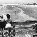
The “Grand Modell of Charlestown,” the original blueprint for downtown Charleston, first designated Broad Street as the city’s east-west connector in 1680. The eastern portion of Broad, shown here, was home primarily to merchants and craftsmen during the Colonial period, then was occupied by those in the legal and financial industries, and, in recent years, has become a coveted location for a variety of boutiques, galleries, and eateries. This circa-1933 photograph, taken from the steps of the Old Exchange Building and Provost Dungeon, offers a glimpse of a bustling, early-20th-century Charleston, a time when trolley cars on iron tracks transported downtown denizens from one corner of the peninsula to another. For more than seven decades after the Civil War, a fleet of trolleys dotted the streets, first drawn by horses, then electrified in 1897, before being abandoned entirely in 1938 for more modern diesel buses. Today, residents and visitors can hop aboard the city’s Route 211 free DASH (Downtown Area Shuttle) trolley, which runs along Broad Street every 30 minutes.
Photograph by Morton Brailsford Paine, courtesy of the Charleston Museum